Drones & Payloads

The industry’s best drone mapping solutions are now available at CSDS. DJI drones offer survey professionals the most advanced UAV hardware and software, delivering unparalleled accuracy in digital deliverables. Experience the benefits of timely decision-making, significant cost savings, enhanced personnel safety, and peak efficiency through cutting-edge aerial data collection.
Whether you're performing topographic surveys, generating diverse data outputs, or enhancing every stage of your construction projects with precise visual data, DJI drones provide superior aerial views and data collection capabilities. Equip your projects with the latest generation of DJI professional-grade drones and integrate high-precision LiDAR payload systems for successful and efficient mapping missions.
Discover our range of UAV solutions from DJI to elevate your survey and mapping operations today!
Featured Products
Now Available at CSDS
Wingtra Drones and Sensors
New
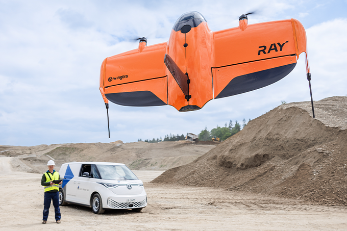
WingtraRAY
The drone made for surveyors
WingtraRAY is Wingtra’s newest survey drone, built for speed, precision, and total confidence in the field. Fly with peace of mind—even over roads and populated areas. Cover up to 100 ha (250 ac) in just 10 minutes and deliver CAD-ready files seamlessly from capture to output. Take on more jobs with purpose-built swappable sensors for high-quality capture across a wide range of survey tasks.

WingtraOne GEN II
Survey more in a single flight!
From highways and industrial complexes to mines, take on larger projects that were once beyond a drone's reach—all in just a few hours.

Best-In-Class Sensors
High quality, swappable, and durable!
Enhance your mapping results with top-tier sensors like the RGB61 MP full-frame camera and advanced LiDAR, each delivering exceptional resolution and accuracy.

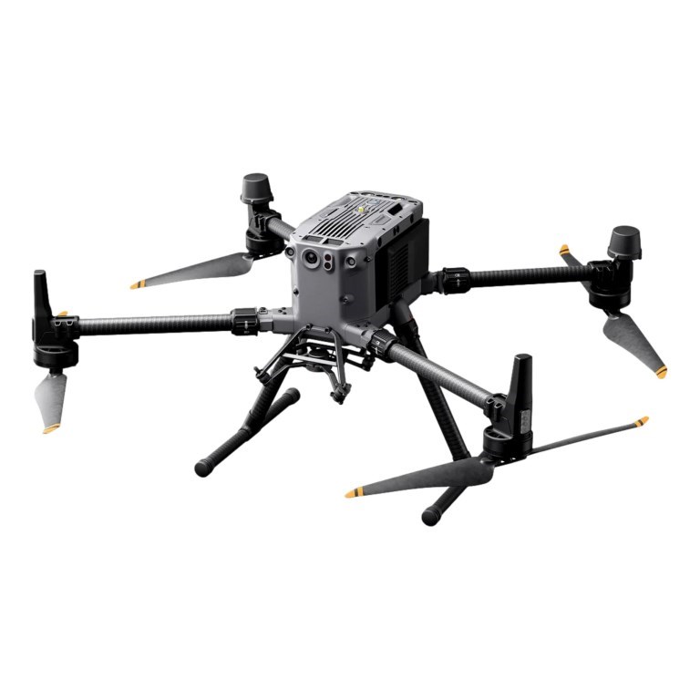
DJI Matrice 350 RTK
Fully powered to forge ahead.
This next-generation drone platform features an all-new video transmission system and control experience, a more efficient battery system, and more comprehensive safety features, as well as robust payload and expansion capabilities. It is fully powered to inject innovative strength into any aerial operation.
- Powerful flight performance
- New transmission system
- New control experience
- Upgraded battery system
- Enhanced flight safety
- Powerful payloads

55-min Max Flight Time[1]

IP55 Rating[2]

DJI O3 Enterprise Transmission

DJI RC Plus

400 Battery Cycles[3]

6-Directional Sensing & Positioning

Night-Vision FPV Camera

Multi-Payload Support
- Measured with Matrice 350 RTK flying at approximately 8 m/s without payloads in a windless environment until the battery level reached 0%. Data is for reference only. Please pay attention to reminders in the app for the actual usage time.
- Measured in a controlled environment. The IP rating is not permanently effective and may decrease due to product wear and tear.
- Up to 400 cycles if the accumulative duration of battery level ≥ 90% is less than 120 days within 12 months.
Choose an Enterprise Care Plan

DJI Matrice 350 RTK Enterprise Care Basic 1 Year Bundle Includes 2 Flight Batteries and Battery Station
Model #902171

DJI Matrice 350 RTK Enterprise Care Basic 2 Year Bundle Includes 2 Flight Batteries and Battery Station
Model #902172

DJI Matrice 350 RTK Enterprise Care Plus 1 Year Bundle Includes 2 Flight Batteries and Battery Station
Model #902173
DJI Matrice 300 RTK Enterprise Care Basic 1 Year Bundle Includes 2 Flight Batteries and Battery Station
Model #902141

DJI Mavic 3 Enterprise Series
Your everyday commerical drone.
The Mavic 3 Enterprise Series redefines industry standards for small commercial drones. With a mechanical shutter, a 56× zoom camera, and an RTK module for centimeter-level precision, the Mavic 3E brings mapping and mission efficiency to new heights.

Compact and Portable

4/3 CMOS Wide Camera[1]

56× Hybrid Zoom

640 × 512 px Thermal Camera [2]

45-min Max Flight Time[3]

DJI O3 Enterprise Transmission

Centimeter-level Positioning with RTK [4]

High-Volume Loudspeaker [4]
- Available for Mavic 3E only.
- DO NOT expose the thermal camera lenses to strong sources of energy such as the sun, lava, or a laser beam. Otherwise, the camera sensor may be burned leading to permanent damage.
- Measured at 32.4 kph uniform speed at sea level in a windless environment. For reference only. Please pay attention to the DJI Pilot 2 App for return flight tips when actually flying.
- Accessories sold separately.
Choose an Enterprise Care Plan

DJI Mavic 3 E Enterprise Care Basic 1 Year Bundle Includes RTK Module, Battery Charging Hub and 4 Flight Batteries
Model #902143
DJI Mavic 3 E Enterprise Care Basic 2 Year Bundle Includes RTK Module, Battery Charging Hub and 4 Flight Batteries
Model #902144
DJI Mavic 3 E Enterprise Care Plus 1 Year Bundle Includes RTK Module, Battery Charging Hub and 4 Flight Batteries
Model #902145

Zenmuse P1
Efficiency through flexible full-frame photogrammetry.
The Zenmuse P1 integrates a full-frame sensor with interchangeable fixed-focus lenses on a 3-axis stabilized gimbal. Designed for photogrammetry flight missions, it takes efficiency and accuracy to a whole new level.

Accuracy without GCPs 3 cm horizontally / 5 cm vertically[1]

High Efficiency 3 km2 covered in a single flight[2]

Global Mechanical Shutter[3] Shutter Speed 1/2000 Seconds

45 MP Full-frame Sensor

3-axis Stabilized Gimbal Smart Oblique Capture

TimeSync 2.0 - Synchronization at the Microsecond Level
- Using Mapping Mission at a GSD of 3 cm, with an 75% front overlap rate and a 55% side overlap rate.
- At a GSD of 3 cm, with an 75% front overlap rate and a 55% side overlap rate.
- The global shutter is achieved with a central leaf shutter.

Zenmuse L2
High Precision Aerial LiDAR System
Zenmuse L2 is the newest integrated LiDAR solution that provides DJI flight platforms with more precise, efficient, and reliable geospatial data acquisition. Supported by its powerful hardware, L2 delivers a highly accurate scan of complex subjects within an extended range and faster point cloud acquisition.
Compatible with the Matrice350 RTK and Matrice300 RTK

High Precision Vertical Accuracy: 4 cm; Horizontal Accuracy: 5 cm [1]

Exceptional Efficiency: 2.5 km2 covered in a single flight [2]

Superior Penetration: Smaller laser spots, denser point clouds

Detection Range [3]: 250m @10% reflectivity, 100klx 450m @50% reflectivity, 0klx

5 Returns

Turnkey Solution [4]

Point Cloud LiveView

Intuitive Operation: Simple to use. Delivers seamless end-to-end surveying workflows
- Measured under the following conditions in a DJI laboratory environment: Zenmuse L2 mounted on a Matrice 350 RTK and powered on. Using DJI Pilot 2’s Area Route to plan the flight route (with Calibrate IMU enabled). Using repetitive scanning with the RTK in FIX status. The relative altitude was set to 150 m, flight speed to 15 m/s, gimbal pitch to -90°, and each straight segment of the flight route was less than 1500 m. The field contained objects with obvious angular features, and used exposed hard ground checkpoints that conformed to the diffuse reflection model. DJI Terra was used for post-processing with Optimize Point Cloud Accuracy enabled. Under the same conditions with Optimize Point Cloud Accuracy not enabled, the vertical accuracy is 4 cm and the horizontal accuracy is 8 cm.
- Measured with Zenmuse L2 mounted on Matrice 350 RTK with a flight speed of 15 m/s, flight altitude of 150 m, side overlap rate of 20%, Calibrate IMU enabled, Elevation Optimization turned off, and terrain follow turned off.
- The data presented are typical values. Measured using a flat subject with a size larger than the laser beam diameter, a perpendicular angle of incidence, and an atmospheric visibility of 23 km. In low-light environments, the laser beams can achieve the optimal detection range. If a laser beam hits more than one subject, the total laser transmitter power is split and the achievable range is reduced. The maximum detection range is 500 m.
- After power is turned on, the IMU doesn't require warm-up; however, users must wait for the drone RTK to be in the FIX status before it can fly and work.
Choose an Enterprise Care Plan

DJI Zenmuse L2 Bundle With Enterprise Care Basic 1 Year Warranty
Model #902241
DJI Zenmuse L2 Bundle With Enterprise Care Basic 2 Year Warranty
Model #902242
DJI Zenmuse L2 Bundle With Enterprise Care Plus 1 Year Warranty
Model #902243